
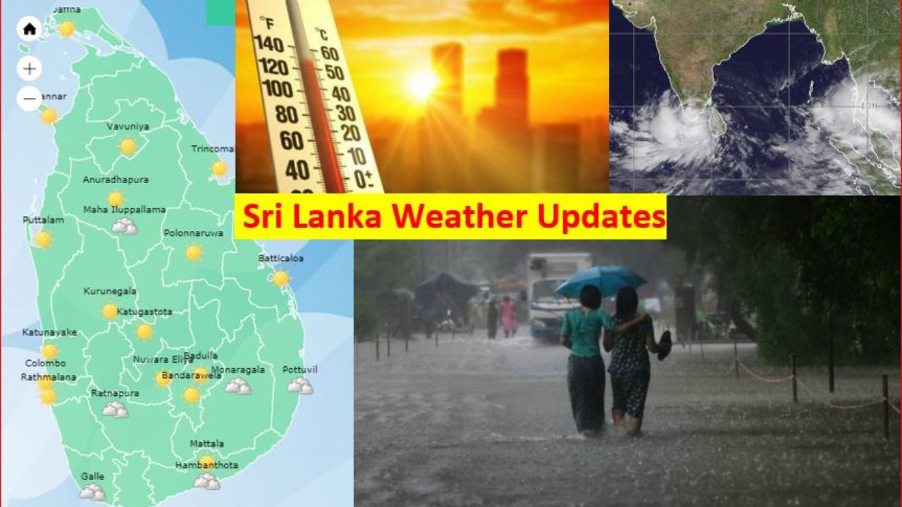
Sri Lanka Weather Updates and Alerts via MET
Sri Lanka weather updates via MET. (May 13 Report) The showery condition over South-western and North-western part of the island is likely to enhance to some extent during next few days due to cyclonic storm (Tauktae).
- Minor flood situation several areas. Water level rising in Kelani ganga (Hanwella), Kalu Ganga (Millakanda), Gan Ganga ( Baddegama), Nilwala Ganga (Panadugama), Attanagalu Oya ( Dunamale, Giriulla)
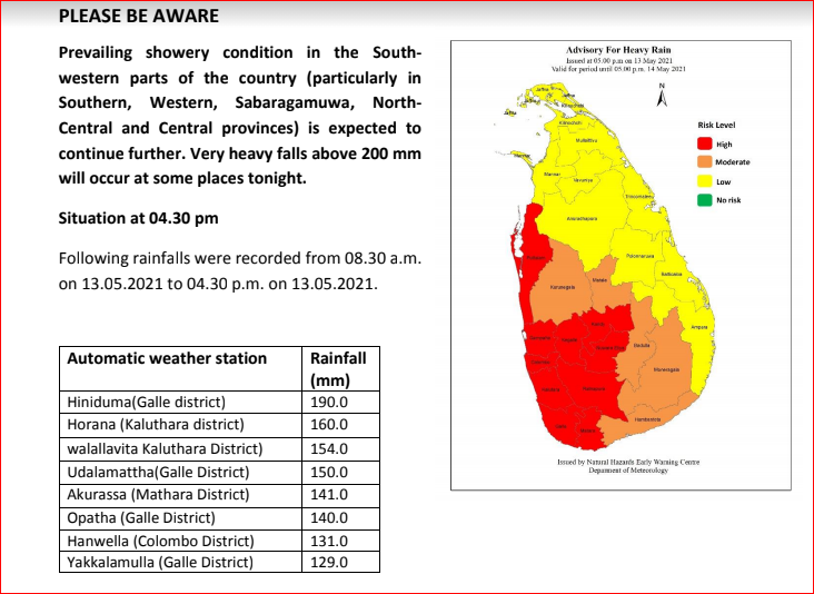
- 13th May 1730hrs (MET); Warning for heavy Rain for Land Areas Prevailing showery condition in the South-western parts of the country (particularly in Southern, Western, Sabaragamuwa, North-Central and Central provinces) is expected to continue further. Very heavy falls above 200 mm will occur at some places tonight.
- 13th May 1700 hrs (Irriga. Dept.) ; Water levels observed Minor Flood level at Millakanda area in Kalu Ganga. People living at downstream (Bulathasinhala, Palindanuwara, Millenia, Horana, Dodangoda and Kalutara) need to be vigilant on possible floods.
- 13th May 1730 hrs (Irriga. Dept.) ; Water levels observed Minor Flood level at Udugama area in Gin Ganga. People living at downstream (Udugama, Mapalagama, Nagoda, Unanvitiya, Welivitiya, Baddegama and Holuwagoda) need to be vigilant on possible floods.
- 13th May 1740 hrs (Irriga. Dept.) ; Water levels observed Minor Flood level at Panadugama area in Nilwala Ganga. People living at downstream (Pitabeddara. Akuressa, Kanduwa, Malimbada, Kamuburupitiya, Thihagoda, and Athuraliya) need to be vigilant on possible floods.
- 13th May 1600hrs (NBRO); Landslide Early Warning (valid until 1500hrs 14 May 2021). Level 2 – Alert ; Kalutara District (Agalawatta,Walallawita,Bulathsinhala,Palindanuwara,Ingiriya,Mathugama and Dodangoda DS Divisions). Level 1 – Watch; Galle District (Niyagama,Elpitiya,Nagoda,Neluwa,Baddegama,Thawalama and Yakkalamulla).
- A low-pressure area has formed over southeast Arabian sea and adjoining Lakshadweep. It is very likely to concentrate into a depression during next 48 hours. The system is likely to move nearly north-northwestwards towards Gujarat and Pakistan coast around 18th May evening.
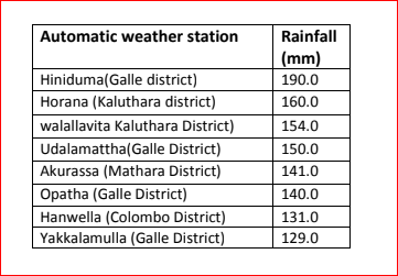
- Recorded rainfall last 8-hours
NBRO issued Level 2 Alert for several DS divisions in Kalutara and Galle District district.
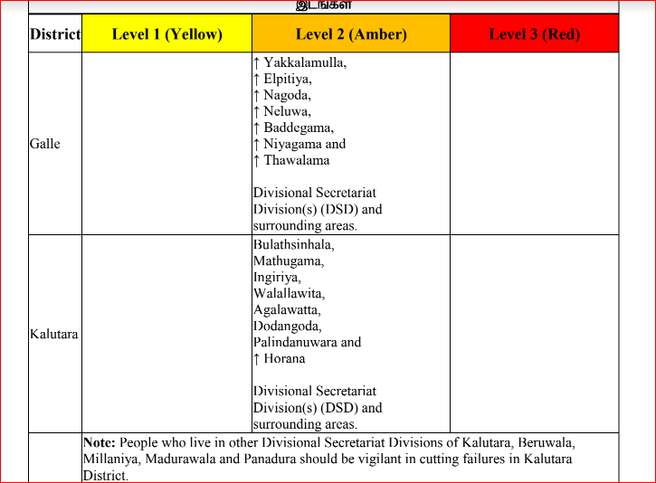
People living in Bulathsinhala,Palindanuwara,Agalawatta,Walallawita,Ingiriya,Mathugama and Dodangoda Divisional Secretariat Division(s) (DSD) and surrounding areas are requested to be vigilant. Level 1 Alert issued for Horana.
NBRO issued Level 1 Watch Alert for several DS divisions in Galle district. Niyagama, Elpitiya, Nagoda, Neluwa, Baddegama, Thawalama and Yakkalamulla Divisional Secretariat Division(s) (DSD) andsurrounding areas. People living in those areas are requested to be vigilant.
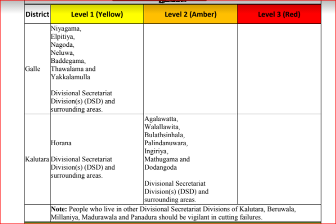
NBRO issued Level 1 Watch Alert for several DS divisions in Kalutara district.
People living in Bulathsinhala,Palindanuwara,Agalawatta,Walallawita,Ingiriya,Mathugama and Dodangoda Divisional Secretariat Division(s) (DSD) and surrounding areas are requested to be vigilant.
According to the MET, There is a possibility to develop a low pressure area in the southeast Arabian sea area around 14th May. It is likely move North-westward and very likely to intensify further in to a cyclonic storm (Tauktae) during next few days. Under the influence of the system, possibility for heavy showers or thundershowers and sudden roughness, associated with sudden increase of wind speed up to 60-70 kmph is high in deep and shallow see areas extending from Kankasanturai to Hambanthota via Mannar, Colombo and Galle during next few days.
According to the Lead International Forecaster Jason Nicholls the Depression, then cyclonic storm likely to form in the Arabian Sea Friday and this weekend. Developing system can brush SW India with heavy rain this weekend. The window for possible impacts from land falling cyclone next week looks to be from Oman to Pakistan & Gujarat.
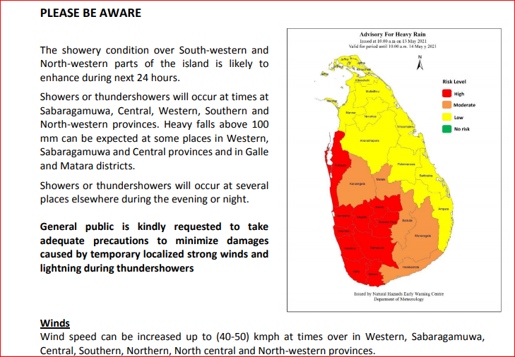
Showers or thundershowers at times will occur at Sabaragamuwa, Central, Western, Southern and North-western provinces. Showers or thundershowers will occur at several places elsewhere during the evening or night. Heavy falls above 100 mm can be expected at some places in Western, Sabaragamuwa and Central provinces and in Galle and Matara districts. Wind speed can increase up to (40-50) kmph at times over in Northern, North central and North-western provinces and in Hambanthota district. General public is kindly requested to take adequate precautions to minimize damages caused by temporary localized strong winds and lightning during thundershowers.
Showers or thundershowers will occur over most parts of the island during the evening or night. Showers can occur over Eastern province and in Hambanthota district during the morning.
Fairly heavy rainfalls above 75 mm can be expected at some places in Sabaragamuwa, Central, Western, Uva, North-western and Southern provinces.
General public is kindly requested to take adequate precautions to minimize damages caused by temporary
localized strong winds and lightning during thundershowers.
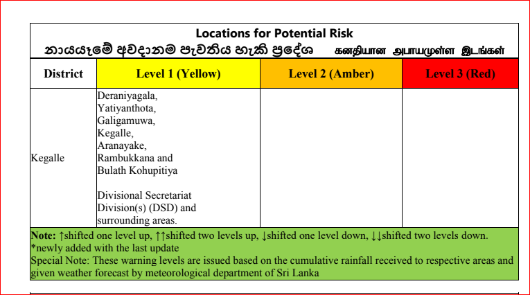
Landslides Level 1 Alert issued for Kegalle district. Deraniyagala, Yatiyanthota, Galigamuwa, Kegalle, Aranayake, Rambukkana, Bulathkohupitiya areas.
Heavy rainfalls above 100 mm can be expected at some places in Sabaragamuwa, Central, Western and North-western provinces and in Polonnaruwa, Galle and Matara districts.
General public is kindly requested to take adequate precautions to minimize damages caused by temporary localized strong winds and lightning during thundershowers.
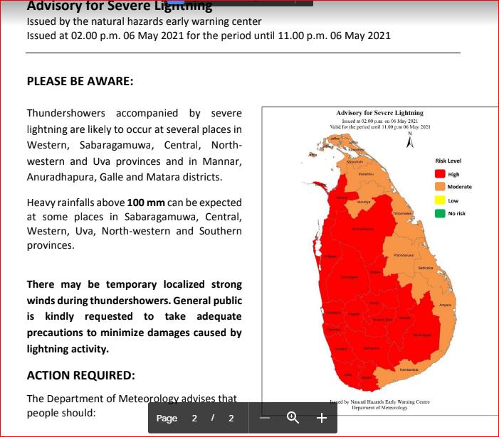
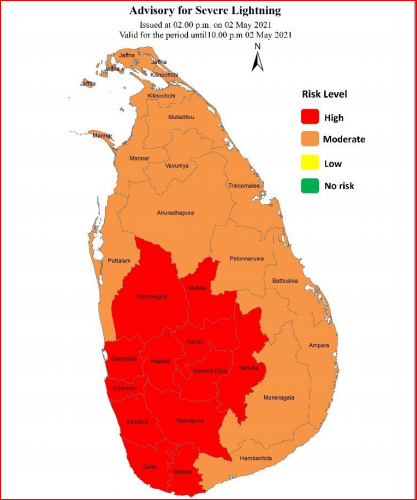
Advisory for Severe Lightning – PLEASE BE AWARE:
Thundershowers accompanied by severe lightning are likely to occur at several places in Sabaragamuwa, Central and Western provinces and in Galle, Matara, Kurunegala and Badulla districts.
There may be temporary localized strong winds during thundershowers. General public is kindly requested to take adequate precautions to minimize damages caused by lightning activity.
Heavy rainfalls above 100 mm can be expected at some places in Western, Sabaragamuwa, Central and North-western provinces and in Galle and Matara districts.
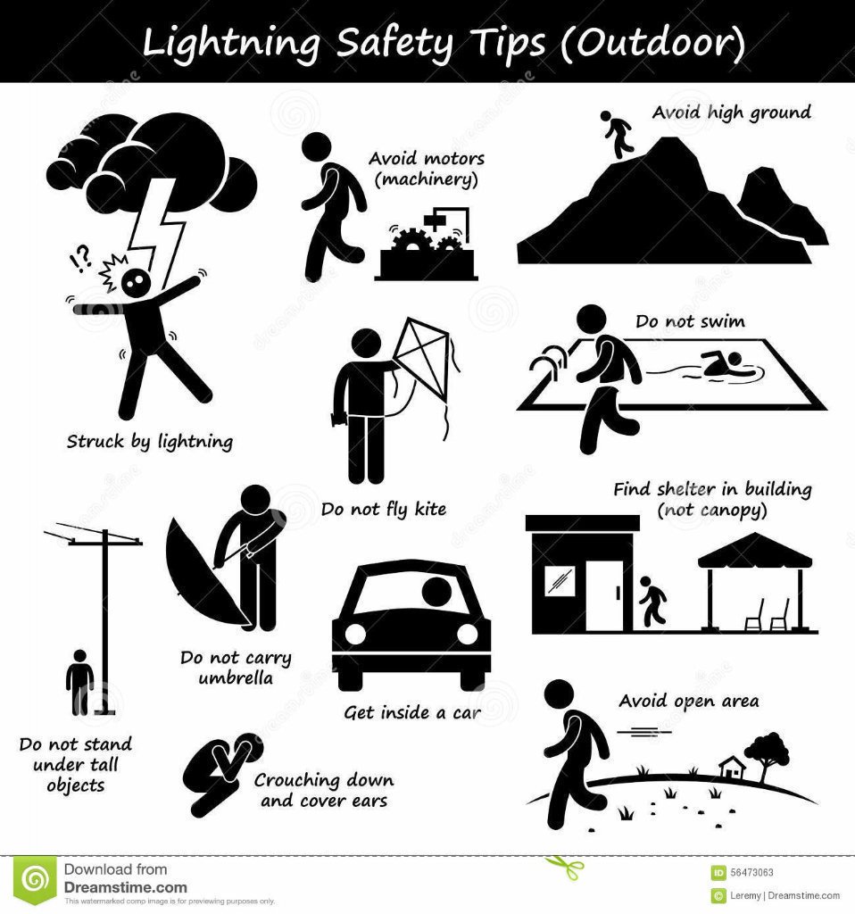
ACTION REQUIRED:
The Department of Meteorology advises that
people should:
Seek shelter, preferably indoors and never
under trees.
Avoid open areas such as paddy fields, tea plantations and open water bodies during
thunderstorms.
Avoid using wired telephones and connected electric appliances during thunderstorms.
Avoid using open vehicles, such as bicycles, tractors and boats etc.
Beware of fallen trees and power lines.
For emergency assistance contact the local disaster management authorities.
Showers or thundershowers will occur in most parts of the island during the evening or night. Heavy rainfalls above 100 mm can be expected at some places in Sabaragamuwa, Central, Western and North-western provinces and in Polonnaruwa, Galle and Matara districts.
General public is kindly requested to take adequate precautions to minimize damages caused by temporary localized strong winds and lightning during thundershowers.
Sri Lanka weather updates via MET. Heavy Rains, Monsoon, Floods, Cyclone and Weather Updates and Alerts.
Lightening Alert!
Increase in Thunder and Lightning activities (Bakmaha Akunu) during April month and May. General public is kindly requested to take adequate precautions to minimize damages caused by temporary localized strong winds and lightning during thundershowers.
Lightning ⚡ safety tips.
1️⃣ Seek shelter (indoors)
2️⃣ Avoid using wired telephones
3️⃣ Avoid open areas
4️⃣ Avoid using open vehicles
5️⃣ Do not swim
Thundershowers / Heavy Rain Alert!
ACTION REQUIRED:
The Department of Meteorology advises that people should:
- Seek shelter, preferably indoors and never under trees.
- Avoid open areas such as paddy fields, tea plantations and open water bodies during thunderstorms.
- Avoid using wired telephones and connected electric appliances during thunderstorms.
- Avoid using open vehicles, such as bicycles, tractors and boats etc.
- Beware of fallen trees and power lines.
- For emergency assistance contact the local disaster management authorities.