
Low pressure area Arabian sea and to a cyclonic storm Tauktae and move towards India. Expect heavy rains and strong winds !
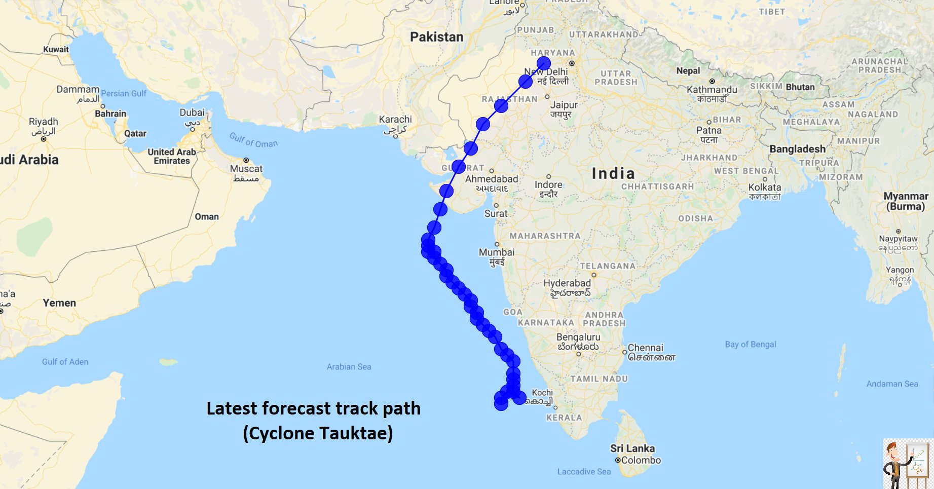
Weather Update – According to the MET, The low pressure area over south east Arabian has developed into a depression and lay centered at 08.30 a.m. of today, the 14th May 2021, near latitude 10.5°N and longitude 72.3°E. It is very likely to intensify into deep depression within next 12 hours. The system is likely to move nearly northnorthwestwards towards Gujarat coast around 18th May morning.
The impact of this system, on weather over the island is expected to reduce gradually from tomorrow May 15.
Several spells of showers will occur in Western, Sabaragamuwa, Central and North-western provinces and in Galle and Matara districts. A few showers will occur in Northern and Northcentral provinces. Showers or thundershowers will occur at a few places in Eastern and Uva provinces during the evening or night. Fairly heavy falls about 75 mm can be expected at some places in Ratnapura, Kegalle, Galle, Matara and Kaluthara districts.
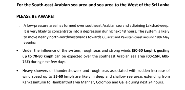
There is a possibility to develop a low pressure area in the southeast Arabian sea area around 14th May. It is likely move North-westward and very likely to intensify further in to a cyclonic storm (Tauktae) during next few days. Under the influence of the system, possibility for heavy showers or thundershowers and sudden roughness, associated with sudden increase of wind speed up to 60-70 kmph is high in deep and shallow see areas extending from Kankasanturai to Hambanthota via Mannar, Colombo and Galle during next few days.
According to the Lead International Forecaster Jason Nicholls the Depression, then cyclonic storm likely to form in the Arabian Sea Friday and this weekend. Developing system can brush SW India with heavy rain this weekend. The window for possible impacts from land falling cyclone next week looks to be from Oman to Pakistan & Gujarat.
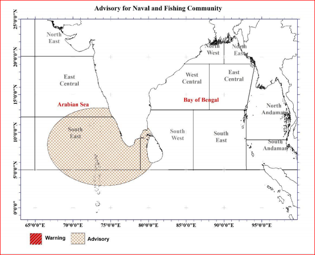
Advisory for the development of Low Pressure Area in South-east Arabian Sea Issued by the Natural Hazards Early Warning Centre
For the South-east Arabian sea area and sea area to the West of the Sri lanka
PLEASE BE AWARE! ·
There is a possibility to develop a low pressure area in the southeast Arabian sea area around 14th May. It is likely move North-westward and very likely to intensify further in to a cyclonic storm during next few days.
As such, sudden roughness of the sea associated with strong winds (50-60 kmph, up to 70-80 kmph gusty wind at times) during thundershowers are expected over the southeast Arabian sea area (00-12N, 60E-75E) during next few days.
Under the influence of the system, possibility for heavy showers or thundershowers and sudden roughness, associated with sudden increase of wind speed up to 60-70 kmph is high in deep and shallow see areas extending from Kankasanturai to Hambanthota via Mannar, Colombo and Galle during next few days.
ACTION SUGGESTED:
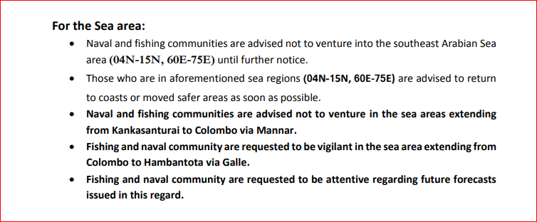
For the Sea area:
Naval and fishing communities are advised not to venture into the southeast Arabian sea area (00-12N, 60E-75E) from 14 May, until further notice.
Those who are in aforementioned sea regions (00-12N, 60E-75E) are advised to return to coasts or moved safer areas as soon as possible.
Fishing and naval communities are in the deep and shallow see areas extending from Kankasanturai to Hambanthota via Mannar, Colombo and Galle, be vigilant in this regard.
Fishing and naval community are requested to be attentive regarding future forecasts issued in this regard.
The showery condition over South-western and North-western part of the island is likely to enhance to some extent during next few days. Showers or thundershowers at times will occur at Sabaragamuwa,Central,Western and North-western provinces and in Galle and Matara districts.
Showers or thundershowers will occur at several places in Eastern and Uvaprovinces and in Hambanthota district during the evening or night. Heavy falls about 100 mm can be expected at some places in Western,Sabaragamuwa and Central provinces and in Galle and Matara districts.
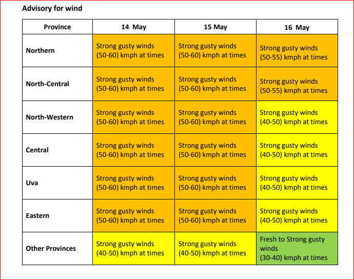
Wind speed can increase up to (40-50) kmph at times over in Northern, North central and North-western provinces and in Hambanthota district.
General public is kindly requested to take adequate precautions to minimize damages caused by temporary localized strong winds and lightning during thundershowers.