
Weather Forecast For October 23
Updated —
Showers or thundershowers will occur at times in Western, Sabaragamuwa, Central, North-Western and Northern provinces and in Galle and Matara districts. Heavy showers above 100 mm may be expected at some places in Western, Sabaragamuwa and Northern provinces and in Galle and Matara districts.
Showers or thundershowers may occur elsewhere over the Island during the afternoon or night.
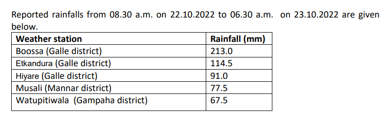
Massive rainfall of 213mm was reported in Boossa (Galle district) area.
NBRO issued landslides Warning Level 2 Alert. Ambagamuwa DS in Nuwara Eliya District. Dodangoda, Bulathsinhala, Ingiriya, Palindanuwara and Walallawita DS in Kaluthara District. Warning Level 1 Watch. Baddegama DS in Galle District. Agalawatta, Mathugama and Millaniya DS in Kalutara District. Dehiowita, Ruwanwella, Deraniyagala, Yatiyanthota, Bulathkohupitiya, Warakapola and Mawanella DS in Kegalla District. Kuruwita, Nivithigala, Ratnapura, Eheliyagoda and Kalawana DS in Rathnapura District.
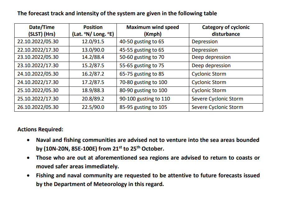
The low-pressure area over north Andaman Sea moved west-northwestward, and concentrated into a depression over southeast adjoining eastcentral Bay of Bengal, close to west of Andaman Islands.
It is very likely to move northwestward and intensify further into a Deep depression over east-central and adjoining southeast Bay of Bengal. Subsequently, it is very likely to move North-northeastwards and cross Bangladesh coast around 25th October.
Wind speeds will be (40-50) kmph and can increase up to (60-80) kmph in sea areas between (10N – 20N) and (85E – 100E). Heavy showers or
General public is kindly requested to take adequate precautions to minimize damages caused by temporary localized strong winds and lightning during thundershowers.
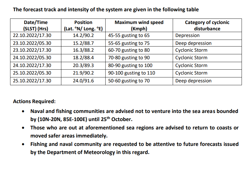
The Low-Pressure Area over north Andaman Sea and adjoining areas of south Andaman Sea & Southeast Bay of Bengal persisted over the same region. It is very likely to move west-northwestwards and intensify into a Depression over same region around 22nd October.
Showers or thundershowers will occur at times in Western, Sabaragamuwa, Central, North-Western and Northern provinces and in Galle and Matara districts. Fairly heavy showers above 50 mm may be expected at some places.
Showers or thundershowers will occur at several palaces in the Eastern and Uva provinces and in Hambantota district during the afternoon or night.
Massive rainfall of 138.5 mm was reported in Tampana – Kurunegala area during last 24-hours.
General public is kindly requested to take adequate precautions to minimize damages caused by temporary localized strong winds and lightning during thundershowers.
The Low-Pressure Area over north Andaman Sea and adjoining areas of south Andaman Sea & Southeast Bay of Bengal persisted over the same region. It is very likely to move west-northwestwards and intensify into a Depression over same region around 22nd October.
It is very likely to intensify into a Deep Depression on 23rd October and subsequently into a cyclonic storm by 24th October. Thereafter, it is likely to move gradually north-northeastwards and reach near West Bengal – Bangladesh coasts on 25th October.
Wind speeds will be (40-50) kmph and can increase up to (60-70) kmph in sea areas between (05N – 17N) and between (85E – 100E).
Heavy showers or thundershowers and very rough or rough seas can also be expected in above sea areas.