
Sri Lanka Weather – Cyclone Yaas over Bay of Bengal. Expect Very Heavy Rains & Strong Winds.
Update – May 23 – Parallel to south west Monsoon establishment, a cyclone Yaas over Bay of Bengal. Under the influence of the system, possibility for very heavy showers or thundershowers and sudden roughness, associated with sudden increase of wind speed up to 60-70 kmph is high in deep and shallow see areas around Sri Lanka during next few days.
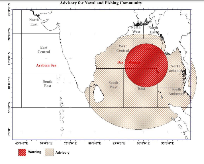
- Cyclone Yaas to landfall India on May 26
- Yaas become Very Severe Cyclonic Storm Maximum wind speed 155-165kmph gusting to 185kmph
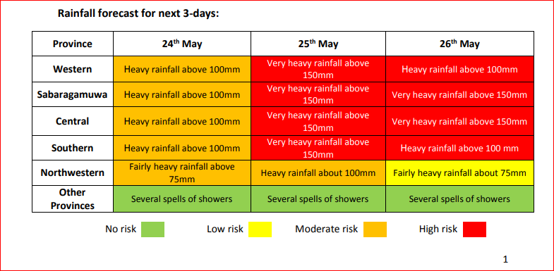
- Expect very heavy rains over 150 mm in Sri Lanka
- Western, Sabaragamuwa, Central and Southern provinces to receive over 150mm rainfall which may lead to flood situation
- Strong Winds / Wind speed can be increased up to 70 kmph at times
- South-west monsoon has established over Sri Lanka
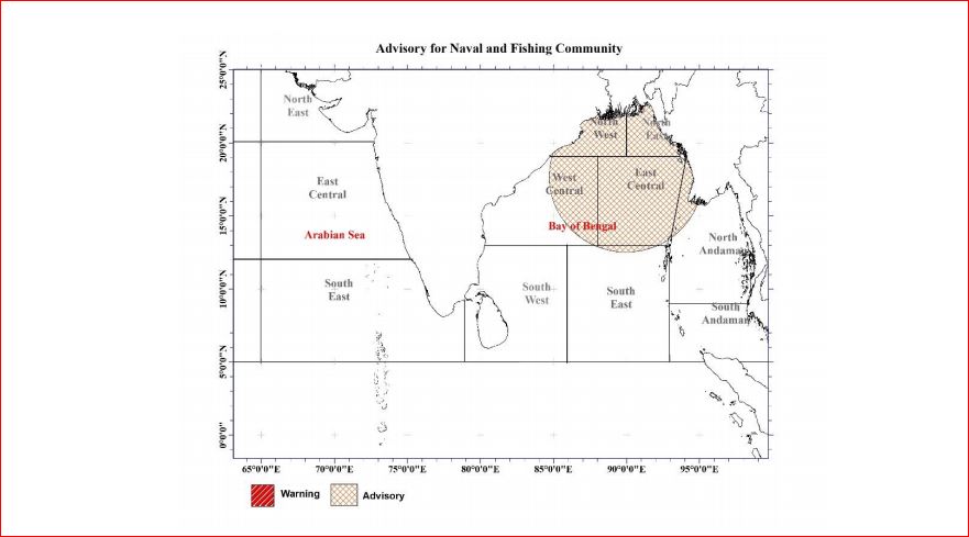
- Naval and fishing communities are advised not to venture into the East Central Bay of Bengal
- Water levels of major rivers rising
- Minor Floods reporting near several rivers
- Landslide warning has issued to Galle, Kalutara, Ratnapura, Kegalle, Nuwara Eliya and Kandy districts
Cyclone Yaas Update – Daily Weather Update – Monsoon Update article
May 21 – In anticipation of formation of the low pressure area is very likely to form over north Andaman Sea and adjoining East-central Bay of Bengal around 22nd May, 2021. It is very likely to intensify gradually into a cyclonic storm during subsequent 72 hours. A low-pressure area is likely to form over East Central Bay of Bengal and adjoining areas around 23rd May 2021. The rainy condition over South-western part (Western, Sabaragamuwa, Central and Southern provinces) of Sri Lanka and the windy condition over Northern and North-Western provinces are likely to enhance during next few days.
- A low-pressure area is likely to form over East Central Bay of Bengal cyclone possible (Yaas)
- Expect heavy rains about 75 mm can be expected at some places in Western, Sabaragamuwa and Central provinces and in Galle and Matara districts.
- Wind speed can be increased up to (40-50) kmph at times
- Naval and fishing communities are advised not to venture into the East Central Bay of Bengal
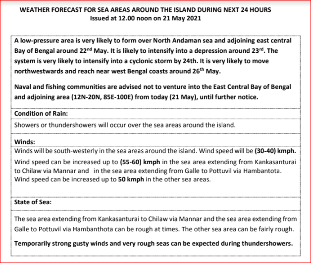
In anticipation of formation of the low pressure area is very likely to form over north Andaman Sea and adjoining East-central Bay of Bengal around 22nd May, 2021. It is very likely to intensify gradually into a cyclonic storm during subsequent 72 hours.
According to Lead International Forecaster Jason Nicholls this low can form in the BOB this weekend with a cyclone possible (Yaas) early next week. System can impact NE India, Bangladesh or Myanmar later next week. Hence NO direct impact to Sri Lanka.
ACTION SUGGESTED:
For the Sea area:
Naval and fishing communities are advised not to venture into the East Central Bay of
Bengal and adjoining area (13N-20N, 85E-95E) from 21 May, until further notice.
Those who are in aforementioned sea areas (13N-20N, 85E-95E) are advised to return
to coasts or moved safer areas.
Fishing and naval community are requested to be attentive regarding future
forecasts issued in this regard.
The showery condition over South-western part (Western, Sabaragamuwa, Central and Southern provinces) of the island and the windy condition over Northern and North-Western provinces are likely to enhance during next few days.
Showers or thundershowers will occur at times in Western, Sabaragamuwa, Central and North-western provinces and in Galle and Matara districts. Fairly heavy falls about 50 mm can be expected at some places in Western and Sabaragamuwa provinces and in Galle and Matara districts.
Showers or thundershowers will occur at a few places in Eastern and Uva provinces during the evening or night.
Wind speed can increase up to (40-50) kmph at times in Western slope of the Central hills, Northern, North-central and North-western provinces and in Hambantota district.